Pupils of 1E1 and 1E2,
I have collected your exam scripts, and will commence marking shortly.
I understand that this exam was quite tough for most of you. I did not set the paper, and I hope that at least some of my hints and tips proved to be useful. I would really like to apologise for the fact that quite a number of questions in the paper were about things I did not teach in class. I did try my best to give a crash course, but I apologise that I did not compare my notes and teaching materials with the other teachers beforehand.
And I am also very sorry if any of you got the wrong impression that the hints and tips I provided encompassed the entire scope of the exam. I too did not expect to see a number of edits and changes being made to the exam paper.
It definitely has not been easy for all of you, having to cope with so many changes in teachers over the past year. I wish it did not have to happen to your classes. But it is too late for regrets, and I do hope that all of you at least gave your best for this paper.
In any case, don't worry too much about it. What's done is done. Now is the time for you to focus on the other subjects. You've got Literature and Art tomorrow, and there's History on Friday.
And I hope that the experience from this exam has not completely turned you off Geography. Do try and remember the stuff that you have been taught over the past year, because much of it is directly relevant to the Geography syllabus at the Secondary 2 level and beyond.
All the best for the rest of your subjects.
Wednesday, 3 October 2007
Tuesday, 2 October 2007
Bukit Timah Nature Reserve
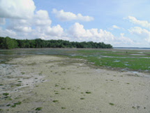
Singapore, lying within the tropical zone, and blessed with high temperature and high rainfall all year round, was once covered with tropical rainforests. It has been estimated that primary rainforest once covered about 82% of the land area of Singapore, approximately 442 km² or 44,200 hectares (ha).
However, ever since people have settled on the island, more and more of the original natural vegetation has been cleared, to make way for settlements and for agriculture and plantations. Today, only 192 ha or 0.43% of the original forest cover remains. Most of the surviving primary forest is restricted to the more pristine areas of the 163ha Bukit Timah Nature Reserve (BTNR), and in scattered patches throughout the 3,043 ha Central Catchment Nature Reserve (CCNR). The remainder of these two nature reserves is occupied mostly by secondary forest.
The Bukit Timah Nature Reserve contains the largest patch of primary rainforest left in Singapore. Bukit Timah Hill, at about 163.63 metres above sea level, is the highest point in Singapore.
A Treasure Trove of Species...
Bukit Timah has been the focus of attention for many scientists, not only because it is a rare example of a rainforest that has managed to survive while completely surrounded by urban development, but also because of the extremely rich diversity of flora and fauna that still exists within the nature reserve. This richness in plant and animal life has been noted ever since the 19th Century.
Back in 1854, the world-famous English naturalist Alfred Russel Wallace visited Singapore to collect beetles. He spent a lot of his time in the vicinity of Bukit Timah, which proved to be an extremely productive place for him: Wallace also mentioned some of the potential dangers he faced, among them the tigers which still prowled the forests in those days:
Today however, Singapore's primary forests are very different from the pristine forests in the rest of Southeast Asia because many of the large animal species are now extinct in Singapore. Tigers disappeared from the Bukit Timah area during the 1920s; the last tiger in Singapore was shot in the mid-1930s. Other large animals, such as leopard, wild boar, sambar deer, and various birds such as hornbills and pheasants have also been wiped out from the forests of Bukit Timah and the Central Catchment Area. Habitat destruction and deliberate hunting and persecution led to these species becoming extinct locally.
Although we have lost a lot of our larger animal species, there is a lot that still survives within our remaining rainforests. Today, it is estimated that BTNR is home to more than 840 flowering plant species and more than 500 species of animals. Scientists are still discovering new species previously unknown to science, and it appears that many of the species living in the BTNR and CCNR are found only in Singapore, and nowhere else in the world!
BTNR: Biodiversity
Within the forest of BTNR, it is dark and cool as the trees form a continuous canopy; very little sunlight reaches the forest floor. On the forest floor, only plants that do not need a lot of sunlight can survive.
Among the various species of plants include hardwood trees such as seraya, keruing and meranti. Palms, rattans, fig trees, lianas, vines and epiphytes are a few other examples of the rich diversity of plant species that can be found within the forest.
The animal life is also extremely rich; most visitors to the reserve will be able to spot one of the most common forest creatures, the long-tailed macaque. Other animals commonly seen include the plantain squirrel, slender squirrel, and common tree shrew. The colugo, also mistakenly known as the flying lemur, is a shy and nocturnal creature, but is often spotted by the sharp-eyed visitor. The forest is also home to many rare and endangered species, such as the lesser mousedeer, Sunda pangolin, and slow loris.
A large proportion of our native bird species are found within the rainforests of BTNR and CCNR, and virtually nowhere else in Singapore. Similarly, the forest is the habitat for a large number of species of lizards, frogs, and snakes that depend heavily on pristine, undisturbed rainforest. The rainforest is also home to a great diversity of insects and spiders; it is impossible not to hear the incessant call of the cicadas, and it is common to spot the huge webs spun by the golden orb web spider. Small streams flowing through the nature reserves are the last refuge for many native fish and other aquatic lifeforms such as freshwater prawns and crabs. In fact, Singapore has three endemic species of freshwater crab found only within streams in BTNR and CCNR. These species are found exclusively in pristine and undisturbed streams that flow through these nature reserves, and are found nowhere else in the world.
Importance of Tropical Rainforests in Singapore
Even though we do not possess very large areas of tropical rainforests, as compared to other countries like Malaysia, Indonesia, Congo and Brazil, our few remaining rainforests are still very important, for various reasons.
National Parks Board: Bukit Timah Nature Reserve
wildsingapore: Bukit Timah Nature Reserve
Ecology Asia: Bukit Timah Nature Reserve - a precious remnant of primary rainforest
Singapore's vest-pocket park: a rainforest survives within sight of skyscrapers
An Inordinate Fondness for Beetles
The Prowling Naturalist: Bukit Timah I: Alfred Russel Wallace in the Malay Archipelago
The Prowling Naturalist: Bukit Timah II: Visiting the Reserve
However, ever since people have settled on the island, more and more of the original natural vegetation has been cleared, to make way for settlements and for agriculture and plantations. Today, only 192 ha or 0.43% of the original forest cover remains. Most of the surviving primary forest is restricted to the more pristine areas of the 163ha Bukit Timah Nature Reserve (BTNR), and in scattered patches throughout the 3,043 ha Central Catchment Nature Reserve (CCNR). The remainder of these two nature reserves is occupied mostly by secondary forest.
The Bukit Timah Nature Reserve contains the largest patch of primary rainforest left in Singapore. Bukit Timah Hill, at about 163.63 metres above sea level, is the highest point in Singapore.
A Treasure Trove of Species...
Bukit Timah has been the focus of attention for many scientists, not only because it is a rare example of a rainforest that has managed to survive while completely surrounded by urban development, but also because of the extremely rich diversity of flora and fauna that still exists within the nature reserve. This richness in plant and animal life has been noted ever since the 19th Century.
Back in 1854, the world-famous English naturalist Alfred Russel Wallace visited Singapore to collect beetles. He spent a lot of his time in the vicinity of Bukit Timah, which proved to be an extremely productive place for him:
"Insects were exceedingly abundant and very interesting, and every day furnished scores of new and curious forms. In about two months I obtained no less than 700 species of beetles, a large proportion of which were quite new, and among them were 130 distinct kinds of the elegant Longicorns (Cerambycidae), so much esteemed by collectors. Almost all of these were collected in one patch of jungle, not more than a square mile in extent, and in all my subsequent travels in the East I rarely if ever met with so productive a spot."
"There are always a few tigers roaming about Singapore, and they kill on an average a Chinaman every day, principally those who work on the gambir plantations, which are always made in newly-cleared jungle. We heard a tiger roar once or twice in the evening, and it was rather nervous work hunting for insects among the fallen trunks and old sawpits, when one of these savage animals might be lurking close by, waiting an opportunity to spring upon us."
Although we have lost a lot of our larger animal species, there is a lot that still survives within our remaining rainforests. Today, it is estimated that BTNR is home to more than 840 flowering plant species and more than 500 species of animals. Scientists are still discovering new species previously unknown to science, and it appears that many of the species living in the BTNR and CCNR are found only in Singapore, and nowhere else in the world!
BTNR: Biodiversity
Within the forest of BTNR, it is dark and cool as the trees form a continuous canopy; very little sunlight reaches the forest floor. On the forest floor, only plants that do not need a lot of sunlight can survive.
Among the various species of plants include hardwood trees such as seraya, keruing and meranti. Palms, rattans, fig trees, lianas, vines and epiphytes are a few other examples of the rich diversity of plant species that can be found within the forest.
The animal life is also extremely rich; most visitors to the reserve will be able to spot one of the most common forest creatures, the long-tailed macaque. Other animals commonly seen include the plantain squirrel, slender squirrel, and common tree shrew. The colugo, also mistakenly known as the flying lemur, is a shy and nocturnal creature, but is often spotted by the sharp-eyed visitor. The forest is also home to many rare and endangered species, such as the lesser mousedeer, Sunda pangolin, and slow loris.
A large proportion of our native bird species are found within the rainforests of BTNR and CCNR, and virtually nowhere else in Singapore. Similarly, the forest is the habitat for a large number of species of lizards, frogs, and snakes that depend heavily on pristine, undisturbed rainforest. The rainforest is also home to a great diversity of insects and spiders; it is impossible not to hear the incessant call of the cicadas, and it is common to spot the huge webs spun by the golden orb web spider. Small streams flowing through the nature reserves are the last refuge for many native fish and other aquatic lifeforms such as freshwater prawns and crabs. In fact, Singapore has three endemic species of freshwater crab found only within streams in BTNR and CCNR. These species are found exclusively in pristine and undisturbed streams that flow through these nature reserves, and are found nowhere else in the world.
Importance of Tropical Rainforests in Singapore
Even though we do not possess very large areas of tropical rainforests, as compared to other countries like Malaysia, Indonesia, Congo and Brazil, our few remaining rainforests are still very important, for various reasons.
- Tropical rainforests have taken hundreds of years to develop and once cleared, they are almost impossible to replace. There are many species of plant and animal in the rainforests, most of which are found nowhere else in the world. And when they are destroyed, some species may become extinct and be lost forever. These include plants with medicinal value which have not even been identified and tested. So, rainforests in Singapore now perform the very important role of providing a place for many species to thrive and grow.
- Rainforests in Singapore also provide us with an idea of what Singapore was like at the beginning of the nineteenth century. Singapore was once covered by tropical rainforests. Hence, by looking at the rainforests now, we get a glimpse of what Singapore might have been like then.
- The rainforests form our water catchment areas. When rain falls, the rainwater is trapped by some of the leaves on the trees. The rainwater then drains slowly into the ground and may be collected in the nearby reservoirs. In this way rainforests help us 'catch' the rain and add to our water supply.
- As Singapore becomes increasingly built up, rainforests act as giant 'lungs' by absorbing large amounts of carbon dioxide and producing oxygen in exhange.
- The rainforests are beautiful and scenic, with fresh air and natural surroundings. They provide us with a peaceful alternative to the busy city, and these last bastions of wilderness are places of peace and quiet where Singaporeans can go to enjoy and appreciate nature at its best. They can also be a tourist attraction.
- The rainforests are a legacy of our natural heritage, and it is important to protect and conserve them, keeping them intact for the country's future generations to learn and appreciate the richness of our country's heritage.
National Parks Board: Bukit Timah Nature Reserve
wildsingapore: Bukit Timah Nature Reserve
Ecology Asia: Bukit Timah Nature Reserve - a precious remnant of primary rainforest
Singapore's vest-pocket park: a rainforest survives within sight of skyscrapers
An Inordinate Fondness for Beetles
The Prowling Naturalist: Bukit Timah I: Alfred Russel Wallace in the Malay Archipelago
The Prowling Naturalist: Bukit Timah II: Visiting the Reserve
New Guinea and Singapore
Many of you have asked me questions regarding the way of life of the tribes living in Papua New Guinea and Irian Jaya, compared to the way of life of people living in Singapore. The Blue Marble textbook is quite unclear on this, so I'll try my best to condense the differences into a few points that you might find easier to digest.
The people in New Guinea live in a forest environment. Their activities have very little impact on the physical environment. They do not greatly modify the environment, besides clearing small patches of forest to grow crops.
The people in Singapore however live in an urban environment, which is an example of a human environment. Over the years, the original physical environment has been changed and converted into a human environment. The physical environment has been greatly modified in order to create the modern urban environment. Here, the human features dominate the landscape.
The people who live in New Guinea depend largely on shifting cultivation, where they clear small areas of forest and grow crops for their own use. The forest which they live in provides them with all that they need: land for farming, wild animals for them to hunt, materials for shelters, clothing and tools. Technology is very primitive compared to that of Singapore.
In Singapore, the people do not depend so much on the physical environment around them. Instead, resources are imported from all over the world. Singapore does not depend very heavily on farming, but where there is farming, it is high-technology and not as primitive as the shifting cultivation adopted by the New Guinea tribes. Technology is very advanced, and is extremely important in all aspects of the daily lives of people living in Singapore.
The people in New Guinea have learned to adapt to the physical environment. Their lifestyles are affected by the physical environment.
The people in Singapore have changed the physical environment to suit their needs. The physical environment is affected by their lifestyles.
Note: New Guinea is made up of several political entities. It consists of the country of Papua New Guinea, and the Indonesian provinces formerly collectively known as Irian Jaya. Check this link for details.
Exam Format
Section A: Multiple-Choice Questions [20 marks]
Section B: Mapwork [10 marks]
Section C: Basic Techniques [10 marks]
Section D: Structured Questions [60 marks] Five questions will be provided; choose only FOUR to answer.
Other important links:
Things to bring for the exam
Please remember to bring the following items to the exam.
I must also stress the importance of writing your answers in blue or black ink ONLY. Strictly NO funny colours likegreen, purple, pink or red will be accepted. Even bright blue is pushing the limit a little. I can promise all of you that if I see any answer scripts written in colours other than black or blue, your answer script goes straight into the trash. And even if I deign to be somewhat more merciful, I can still penalise you for not following instructions. I'm not sure how different things are from my time, but back in my time, any pupil who tried to be funny and submitted homework or test papers written in colours other than blue or black was seriously asking for trouble. =P
Besides that, happy studying, and good luck for the exams! =)
- String: While string will be provided for you to tie your writing paper together, there might not be enough string for everyone, or the string provided might be too short for you to measure distances on the topographical map. So please bring your own string. I can recommend that you do what I did back when I was still in secondary school (not too long ago): I brought an entire spool of thread with me in my pencil case.
- Ruler: It amazes me how many students can forget to bring something as essential as a ruler. If you don't have a ruler, how are you going to make sure that your lines are straight? And even more importantly, how are you going to measure distances?
- Protractor: Without a protractor, you will definitely not be able to measure bearing for your mapwork.
- Other stationery such as pens, pencils, correction fluid, erasers, etc. Borrowing from your neighbours will not be allowed during the examination.
I must also stress the importance of writing your answers in blue or black ink ONLY. Strictly NO funny colours like
Besides that, happy studying, and good luck for the exams! =)
Geology
Since one of you has recommended that I put up more hints and tips on Landforms and Rocks (Chapter 7), and also requested more information on fold mountains, I'll cover some of the more important aspects of the chapter here.
As we all know, the Earth has several layers:
(i) Crust
(ii) Mantle
(iii) Core

Examples of fold mountains include:
1. Igneous rock
Igneous rocks are formed by the cooling or hardening of magma and lava beneath or on the Earth's surface.
(i) When magma cools and hardens slowly in the Earth's crust, coarse-grained igneous rocks are formed. Granite is an example of a coarse-grained igneous rock; the individual grains and crystals in the rocks can be seen by the naked eye.
(ii) When lava cools and hardens quickly on the Earth's surface, fine-grained igneous rocks are formed. Basalt is an example of a fine-grained igneous rock; the individual grains and crystals in the rocks are too small to be seen by the naked eye.
2. Sedimentary rock
Sedimentary rocks are formed from the deposition and accumulation of sediments. As the sediments pile up in layers, the weight of the layers on top compresses the layers below. The pressure cements the layers of sediments together, forming sedimentary rock.
Like igneous rocks, sedimentary rocks can be coarse-grained or fine-grained.
(i) Coarse-grained sedimentary rocks are formed from deposits of larger sediments such as sand, gravel and pebbles.
(ii) Fine-grained sedimentary rocks are formed from very fine sediments such as silt, mud and clay.
Weathering involves either the disintegration or decomposition of the rock in situ. No movement of loose rock material is involved. In other words, the rock breaks apart but is not transported anywhere. The major agents of weathering include large changes in temperature, rainwater, freezing water, and plants.
1) Large changes in temperature: Changes in temperature cause the surface of the rock to expand and contract more than the interior of the rock. This weakens the rock and causes cracks to form.

2) Rainwater: As rain falls, the rainwater combines with carbon dioxide in the air to form a very weak acid, which dissolves certain minerals in the rock. Limestone and marble are especially vulnerable to slowly dissolving away in rainwater, forming caves and other features.
3) Freezing water: Water may enter cracks in rocks. In areas where the temperature falls below the freezing point of water, the water will turn into ice when it is cold enough. Water expands as it freezes. The ice now exerts pressure on the walls of the crack, pushing them further apart and widening the crack. Over time, the crack becomes wider and the rock may break apart.

4) Plants: Plants that grow in cracks in rocks can force these cracks to widen due to the roots growing into the rock.
Erosion refers to the wearing away and removal of weathered rock. Movement of loose rock material is involved. In other words, the rock is being worn away while at the same time, loose material is being transported away. The main agents of erosion are water, waves, ice and wind.
1) Water: As water flows over rocks, it will wash away loose material. Also, as water flows, sediments being carried by the water (such as sand grains and pebbles) will scour and scrape against the rocks, eroding away at the material.
2) Waves: Strong waves carry a lot of energy, and the pounding of these waves can remove large amounts of rock. Also, sand, gravel and pebbles carried by these waves can grind and wear away at the rock.
3) Ice: Glaciers are rivers of ice found in mountainous and polar regions. They move extremely slowly, but they pick up and carry away pieces of rock. Also, just like in a river, the material carried by a glacier can scrape and erode away at the surrounding rocks.
4) Wind: In dry areas, winds are strong, and there is little vegetation to hold the loose soil together. Hence materials such as sand and soil will be picked up and carried away by the wind. Also, in strong wind, the sand and soil picked up by the wind will be blasted at rocks, smoothening and polishing these surfaces.
- The Earth
As we all know, the Earth has several layers:
(i) Crust
(ii) Mantle
(iii) Core

- Landforms: Fold Mountains
Examples of fold mountains include:
- Alps in Europe
- Himalayas in Asia
- Rocky Mountains in North America
- Andes in South America
- Atlas Mountains in north Africa
- Rocks
1. Igneous rock
Igneous rocks are formed by the cooling or hardening of magma and lava beneath or on the Earth's surface.
(i) When magma cools and hardens slowly in the Earth's crust, coarse-grained igneous rocks are formed. Granite is an example of a coarse-grained igneous rock; the individual grains and crystals in the rocks can be seen by the naked eye.
(ii) When lava cools and hardens quickly on the Earth's surface, fine-grained igneous rocks are formed. Basalt is an example of a fine-grained igneous rock; the individual grains and crystals in the rocks are too small to be seen by the naked eye.
2. Sedimentary rock
Sedimentary rocks are formed from the deposition and accumulation of sediments. As the sediments pile up in layers, the weight of the layers on top compresses the layers below. The pressure cements the layers of sediments together, forming sedimentary rock.
Like igneous rocks, sedimentary rocks can be coarse-grained or fine-grained.
(i) Coarse-grained sedimentary rocks are formed from deposits of larger sediments such as sand, gravel and pebbles.
(ii) Fine-grained sedimentary rocks are formed from very fine sediments such as silt, mud and clay.
Limestone however, is formed from the fossilised remains of ancient plants and animals.
3. Metamorphic rock
Sometimes, under extreme heat and pressure, igneous and sedimentary rocks may be completely transformed into a different rock type altogether - metamorphic rock.
- Weathering & Erosion
Weathering involves either the disintegration or decomposition of the rock in situ. No movement of loose rock material is involved. In other words, the rock breaks apart but is not transported anywhere. The major agents of weathering include large changes in temperature, rainwater, freezing water, and plants.
1) Large changes in temperature: Changes in temperature cause the surface of the rock to expand and contract more than the interior of the rock. This weakens the rock and causes cracks to form.

2) Rainwater: As rain falls, the rainwater combines with carbon dioxide in the air to form a very weak acid, which dissolves certain minerals in the rock. Limestone and marble are especially vulnerable to slowly dissolving away in rainwater, forming caves and other features.
3) Freezing water: Water may enter cracks in rocks. In areas where the temperature falls below the freezing point of water, the water will turn into ice when it is cold enough. Water expands as it freezes. The ice now exerts pressure on the walls of the crack, pushing them further apart and widening the crack. Over time, the crack becomes wider and the rock may break apart.

4) Plants: Plants that grow in cracks in rocks can force these cracks to widen due to the roots growing into the rock.
Erosion refers to the wearing away and removal of weathered rock. Movement of loose rock material is involved. In other words, the rock is being worn away while at the same time, loose material is being transported away. The main agents of erosion are water, waves, ice and wind.
1) Water: As water flows over rocks, it will wash away loose material. Also, as water flows, sediments being carried by the water (such as sand grains and pebbles) will scour and scrape against the rocks, eroding away at the material.
2) Waves: Strong waves carry a lot of energy, and the pounding of these waves can remove large amounts of rock. Also, sand, gravel and pebbles carried by these waves can grind and wear away at the rock.
3) Ice: Glaciers are rivers of ice found in mountainous and polar regions. They move extremely slowly, but they pick up and carry away pieces of rock. Also, just like in a river, the material carried by a glacier can scrape and erode away at the surrounding rocks.
4) Wind: In dry areas, winds are strong, and there is little vegetation to hold the loose soil together. Hence materials such as sand and soil will be picked up and carried away by the wind. Also, in strong wind, the sand and soil picked up by the wind will be blasted at rocks, smoothening and polishing these surfaces.
Monday, 1 October 2007
Where is Irian Jaya?
Some of you might be a little confused by one of the hints I provided:
Case Study: Way of life of the people living in Irian Jaya and Papua New Guinea, compared to the way of life of people living in Singapore* (pgs. 37–41)
Many of you have asked me, "Mr. Kwan, where is Irian Jaya?"
Google is there for a reason. =P
This is a map of the island of New Guinea:

New Guinea is split politically into two roughly equal halves. The eastern half belongs to the independent country of Papua New Guinea (which you would have read about in your textbook). The western half consists of the Indonesian provinces of Papua and West Papua.
Now this is the interesting part. Up until very recently, until 2003 at least, Papua and West Papua were a single province, and the entire province was known as Irian Jaya.
(I hope this is one of those moments when a lightbulb goes off in your head)
Even though the two halves of New Guinea belong to two separate political entities, they are very similar. Similar environment, similar lifestyles, the only major thing that separates them is that there is an imaginary line which separates Papua New Guinea from the half formerly known as Irian Jaya.
So basically, when you see a question in the exam asking you about the way of life of tribes in Irian Jaya, just substitute them with the folks living just across the border, in Papua New Guinea. (^_')
The 4th Element
When I covered the chapter on Weather and Climate, I spoke about 3 elements of weather, namely temperature, rainfall, and wind.
However, there are actually a number of other elements which are not mentioned at all in your textbook. This post will introduce one of these other elements: sunlight.
One thing you'll need to know for your exam is the way in which these 4 elements of weather are interrelated. In other words, how do these elements affect one another?
Sunlight affects temperature. The more sunlight an area receives, the higher the temperature.
Wind and rainfall also affect temperature, but in a different way. The stronger the wind, or the higher the rainfall, the lower the temperature. This is why the air tends to be cooler on windy or rainy days.
Temperature can also affect wind. Higher temperature means that the air is warmed and rises, creating an area of low pressure. The higher the temperature, the warmer the air is, creating an area of very low pressure. Likewise, the lower the temperature, the colder the air is, creating an area of very high pressure. The greater the difference in pressure, the stronger the wind. So strong winds can be formed if you have warm areas of very low pressure close to cool areas of very high pressure .
And lastly, temperature can affect rainfall. Higher temperatures lead to an increase in evaporation, thus resulting to an increase in the amount of water vapour in the atmosphere. More water vapour present in the atmosphere ultimately leads to an increase in rainfall.
How latitude and altitude affect temperature...
***IMPORTANT! THIS IS IN THE EXAM!***
How does latitude affect temperature?
We all know by now that the Earth can be broadly divided into 3 climate types: tropical, temperate and polar. We also know by now that the further we travel from the Equator, the colder it gets. Hence, at the high latitudes, close to 90° North and South, temperatures are much lower than at the Equator.
Why is this so? Why is the temperature in Singapore so different from that in Greenland?
There are various reasons for this. The most important one has to do with what is known as the angle of solar incidence. Angle of solar incidence refers to the angle at which the Sun's rays strike the Earth's surface.

At the Equator, the incoming solar radiation strikes the Earth at a right angle. Hence the heat from the Sun is concentrated and more intense, and is spread over a small area. Also, at this latitude, the Sun's rays travel a short distance through the atmosphere. Because of the shorter distance travelled, Less heat is lost to the atmosphere, and therefore more of the Sun's rays reach the Earth's surface.
On the other hand, at high latitudes, the incoming solar radiation strikes the Earth at an acute angle. The Sun's rays also have to pass through a longer distance in the atmosphere before reaching the Earth's surface. Hence more heat is lost to the atmosphere. Even though the rays which strike the polar regions carry the same amount of heat as the rays which strike the tropical regions, this heat is diffused and dispersed over a large area.
Let's use a flashlight as an analogy:

A represents the Sun's rays hitting the Earth at the Equator. The heat is focused and concentrated over a small area and is more intense.
B represents the Sun's rays hitting the Earth at the North Pole. The heat is diffused and dispersed over a larger area.
I hope you remember that in primary school, you learned that it is hottest at midday, when the Sun is directly overhead, whereas it is cooler in the morning and evenings, when the Sun is lower in the sky. This is the same general principle by which latitude affects temperature.
In summary:
• At different latitudes, the Sun's rays strike the Earth at different angles
• At the Equator, the Sun's rays strike the Earth at a right angle, hence the heat is more intense and concentrated over a small area. Less heat is lost to the atmosphere as the rays travel a shorter distance through the atmosphere.
• At the poles, the Sun's rays strike the Earth at an acute angle, dispersing and diffusing the heat over a larger area. More heat is lost to the atmosphere as the rays travel a longer distance through the atmosphere.
One final note: While it is hot and wet in the tropical regions, it is cold in the polar regions, so cold that most of the precipitation is frozen, and falls as snow.
How does altitude affect temperature?

In actual fact, the atmosphere is NOT warmed by direct contact with the Sun's rays. What really happens is that the Earth's surface absorbs most of the heat. Then, as the Earth's surface warms up, the heat diffuses into the lower layers of the atmosphere, warming it, which in turn transfers some of the heat to the upper layers of the atmosphere.
Of course, this means that the layers of atmosphere closest to the Earth's surface receive the most heat from the Earth's surface.
What happens at high altitudes, such as on mountains, or in the upper layers of the atmosphere, is that at such great height, far from the Earth's surface, there is very little heat reaching this altitude. Most of the heat is being trapped within the lower layers of the atmosphere close to the Earth's surface.
Try and visualise a thermos flask with several layers of cloth wrapped around it. The thermos flask represents the Earth, warmed by heat from the Sun. The layers of cloth represent the layers of the atmosphere, with the layers of cloth closest to the thermos flask representing the layers of atmosphere closest to the Earth's surface. The layers of cloth on the outside would be much cooler, because most of the heat from the thermos flask is trapped in the inner layers of cloth.
In summary:
• The atmosphere is progressively warmed by the heat radiating from the Earth's surface
• The lower layers of the atmosphere closest to the Earth's surface are warmed first, and then subsequently transfer heat to the upper layers. As the heat is transferred upwards, some heat is continuously being lost.
• At high altitudes, there is very little heat left to be transferred at this height.
EOY Exam: Hints
For those of you who have lost the handout I gave out with the list of chapters and sections to emphasise on for the exams (frankly, I'm not surprised if some of you don't even know what I'm talking about), I'm repeating the list here:
Chapter 1: About Geography
• What the study of Geography is about (pgs. 4–5)
• Physical and human environment (pg. 6)
Chapter 2: Earth as Our Home
• Earth as part of the Solar System (pgs. 16–19)
• Earth – Our Provider (pgs. 22–25)
Chapter 3: Physical and Human Environments
• Differences between physical and human environment* (pgs. 30–31)
• Inter-relationships between people and the environment* (pgs. 32–36)
• Case Study: Way of life of the people living in Irian Jaya and Papua New Guinea, compared to the way of life of people living in Singapore* (pgs. 37–41)
Chapter 4: Environments Through Maps
• Latitudes and Longitudes (pgs. 49 – 50)
• Reading topographical maps* (pgs. 56–67)
Chapter 7: Landforms and Rocks
• Structure of the Earth, and how it is being shaped (pgs. 90–91)
• Fold mountains and their formation* (pgs. 101 –102)
• Types of rocks (pgs. 103–105)
• Weathering & erosion* (pgs. 109–112)
Chapter 8: Rivers
• Hydrologic cycle* (pgs. 120–121)
• River systems (pgs. 122–123)
• Rivers and people: Energy* (pgs. 132–133)
Chapter 9: Weather and Climate
• Factors affecting weather and climate (e.g, latitude, altitude)
• Elements of weather and climate* (temperature, rainfall and wind), and how we measure them. (pgs. 142–151)
• Different climatic types (pg. 153)
• Reading climographs* (pg. 153)
Chapter 10: Natural Vegetation
• Relationship between climate and natural vegetation (pgs. 160–161)
• Tropical rainforest and its structure* (pgs. 164–165)
• Case Study: Bukit Timah Nature Reserve* (pgs. 166–169)
• Vegetation of the tropical savannah (pgs. 174–175)
• Natural vegetation and people (pg. 181)
Monday, 17 September 2007
Tropical Savanna: Migration of the herbivores
As all of you should be aware of by now, the tropical grasslands of the world are home to an extremely rich variety of large mammals. Nowhere else is this diversity more apparent than in tropical Africa, where close to 50 different species of antelope, of all shapes, sizes and habits, along with numerous other large herbivores, inhabit various parts of the savannas that span the continent. And this diversity of herbivores feeds a wide variety of carnivores.
Note that not all of the creatures one can find in the savanna are 'true' savanna species; many of them actually prefer forest, but can be found in mixed habitats, such as in areas where the tropical rainforest slowly makes way for woodland, and subsequently turns into savanna. Many of these forest-dwelling animals are also occasionally found in savanna habitat adjacent to the forests where they would normally live. And some of these actually live within the savanna, wherever there is sufficient dense vegetation, bush, or thickets to hide in, such as in gallery forest, which refers to forests that grow along the banks of rivers in areas where it would otherwise be too dry for forest to grow.
By and large, however, the majority of large antelope are savanna inhabitants. Many are adapted to grazing on the grasses, herbs, and other low-growing plants. Others are browsers, choosing to nibble on tender young leaves and shoots from bushes, shrubs and trees. This way, competition between species is minimised, as each species has its own particular preference where it comes to food and habitat. The savanna may seem like a broad, homogeneous space to us, but there is a wide variety of microhabitats and ecological niches available for herbivores to exploit.
One thing that most of the larger savanna-dwelling herbivores have in common is a tendency to live in large herds. Living in large herds has its advantages, and it mostly has to do with avoiding predators. First of all, if you live in a herd, there are so many more pairs of eyes and ears on the alert for any sign of danger. Secondly, if a predator attacks, the fact that there are so many potential targets to choose from means that the likelihood of you becoming the main course for the resident lions or hyenas is so much lesser.
Due to the seasonal nature of the savanna, there are very distinct dry and wet seasons in most tropical grasslands. This has implications for the large numbers of herbivores which depend on an adequate supply of water and grazing. Many of these antelope are tough, and adapted to survive with little water and poor-quality food. These tend to stay put during the dry season. However, there are many other species which depend on having frequent access to water, and depend on tender young grass. When the dry season comes, these herbivores will migrate in huge herds, abandoning their former haunts for new pastures, travelling wherever the rain brings water and fresh green grass.
Migration is such an important part of these animals' lives that in many species, calves must learn to stand up and run with the herd within days or even hours of their birth. For wildebeest, mothers even synchronise their births as well; all will drop their calves within a short span of 2 to 3 weeks. Birth is timed to coincide with the rainy season, as well as to completely overwhelm the local predators so that overall survival rate of newborn calves is higher.
These herds may number in the thousands or even millions, all engaged in the tireless quest for food and water. Migration takes its toll, and many will perish; predators will bring down a few, whereas for others, the exhaustion and strain will be too much to bear. Where migration routes bring the herds across rivers, the death toll can be even higher, and it's not just due to the hungry Nile crocodiles that lie in wait in the water. Many of these rivers have only a few entry and exit points along the steep riverbanks, and for the thousands of hungry and thirsty herbivores, these few spots along the river banks become chokepoints. In the ensuing stampedes, many will be trampled, or drown in the waters from sheer exhaustion.
Wildebeest Migration
All over the tropical savannas of Africa, this beautiful yet harsh drama of life and death has played out for eons, with mighty herds perpetually on the move, chasing the rainclouds in a never-ending quest for fresh grass and water. Today however, many of these migrations are no more; hunting and development has decimated many of the great herds, whereas in some areas, the herds find their old migration routes blocked off with fences and development.
One of the last places where you can still see a surviving example of the great herbivore migrations is in East Africa. Here, more than a million wildebeest, and thousands of zebra and antelope make an annual journey, travelling from the Masai Mara Game Reserve in Kenya to the Serengeti National Park in neighbouring Tanzania, and back again later in the year.
Wildebeest Migration Made Simple
Serengeti Wildebeest Migration route map
This phenomenon attracts countless tourists, who pay to witness first-hand the migration of nearly 1.4 million wildebeest, 360,000 Thomson's gazelle, and nearly 200,000 zebra.
Here's a few more videos that capture the essence of life on the tropical savanna, and show us a slice of the awe-inspiring wildlife spectacle that is the Masai Mara-Serengeti migration:
Some nice videos of waterfalls
Here are a couple of nice little video clips, showing footage of a couple of the world's most famous waterfalls.
First up, we have a snippet from the Planet Earth documentary series, featuring Angel Falls, situated on a tributary of the Carrao River in Venezuela, South America.
http://en.wikipedia.org/wiki/Angel_falls*
And here, we have Victoria Falls, which lies on the Zambezi River between the countries of Zambia and Zimbabwe in southern Africa.
http://en.wikipedia.org/wiki/Victoria_falls*
*(Note: Because Wikipedia can be edited by anybody with Internet access and plenty of spare time, Wikipedia is not always the most accurate and reliable source of information. Vandalism and even blatant planting of misinformation can occur in any article. I would recommend that before immediately accepting the contents of any Wikipedia entry as fact, one should check the article for references, and verify the accuracy of the information first)
Thursday, 6 September 2007
Common Test II Qn 14.
a. (i) Name the instrument shown in Fig. 3.
Stevenson screen
(ii) Explain why this instrument has louvres on its side and why it is always set above ground.
The louvres are there to allow air to pass through.
It is set above the ground so that it would not be affected by heat from the ground.
These features help to ensure that the readings from the six's thermometer in the box are as accurate as possible.
b. (i) Where is the best place to put a rain gauge?
D
(ii) Give two reasons for your choice on why it is the best location.
D is an open area and grass is a poor conductor of heat; this ensures that the rain gauge would not be overheated and cause evaporation of rainfall collected
(iii) Explain why the other locations are not ideal.
A is located near an obstruction, in this case a building
B is located near obstructions such as trees and a building
C is located close to trees, also an obstruction.
All these would affect the amount of rain collected.
c. Define the term 'temperature' and state two factors that will affect it.
Temperature is the degree of hotness and coldness of the air. Altitude, latitude and time of day affect temperature. (pg. 142)
Common Test II Qn 13.
a. (i) What are floodplains?
Floodplains are flat land alongside a river that is covered by water during a flood.
(ii) Explain why many people choose to live on floodplains.
They can get easy access to water and use the fertile soil for farming.
b. How are rivers useful in agricultural activities?
• Dams built to produce hydro-electricity also store water for farmers to irrigate their crops.
• Stored water can allow farmers to grow an extra crop in a dry season
• Reduce the effects of drought
• Enable the transport of stored water to areas where water is needed urgently (pg. 134)
c. (i) What are the three main tributaries of the River Nile?
Blue Nile, White Nile, Atbara (pg. 135)
(ii) Describe the advantages of the Aswan High Dam on the River Nile.
These are the advantages:
• No more floods in Egypt
• More land is irrigated, producing more food
• Electricity is produced from the hydro-electric station
• Lake Nasser can be used by large boats for transport
• Supports a fishing industry (pg. 137)
Common Test II Qn 12.
(i) What is wind?
Wind is the horizontal movement of air from a high pressure area to a low pressure area. (pg. 149)
(ii) Label in Fig. 2 below to show how wind is formed.
This is the exact same question as the one in your worksheets. Why so many of you gave me complete nonsense for this questions is a mystery to me. Especially when you consider that we did this barely a week before the test.
This is what I am looking for:

Common Test II Qn 11.
(i) Draw a well-labeled diagram of a waterfall and explain its formation.
(The diagram is taken from pg. 126 of your textbook)
A waterfall can develop where there is a band of harder rock overlying softer rocks. The river is able to wear away the softer rock more quickly than the hard rock. As a result, a step is formed where the soft rock used to be and water falls over the step. (pg. 126)
(ii) Define the term 'drainage basin'.
A drainage basin is the area which is drained by water running across the surface of the land into a particular set of channels. (pg. 123)
Tuesday, 4 September 2007
Common Test papers - comments
Pupils of 1E1 and 1E2,
I have finished marking your Common Test papers, and to be honest, I have to go sit down and rest for a while. While some of you managed to do quite well, to be frank, I am disappointed with the vast majority of you, who performed way below my hopes and expectations.
I may still be a new teacher, and I may not be the best teacher at that, but the kind of grades I am getting from you is to put it simply, ABSOLUTELY APPALLING.
For many of you, particularly those of you who scored 30 and above, I am thankful that you did put in your effort, and the results show that you have been diligent in your revision and self-study.
For those of you who scored between 20 and 30, I hope you can try harder the next time, especially for the End of Year exam.
However, I am extremely disappointed, and even pissed off with the bunch who scored below 20, with some even getting less than 10 marks. And it's not as if there's only a tiny handful of you miserable maggots out there; there's a total of 24 of you from both classes. And to be honest, many of the answers you gave, even for the questions which I provided during remedial sessions and which were repeated for the test itself, were simply
PURE UNADULTERATED CRAP.
After I finished marking all the papers and tabulating the grades, I ended up questioning myself. Have I done something wrong? Is this the best that my students can give? Did most of you even bother to study for this test at all?! Why should I devote so much time and energy into teaching when it appears to me that all the effort has gone to waste?
Why should I have to slog so hard, preparing worksheets, staying behind to conduct remedial lessons, when it seems that a significant proportion of you don't even care at all? I get people missing from my remedials, even though they are meant to be compulsory. I get people who attend but who are not the slightest bit interested in paying attention. I get pupils who say that they understand everything, only to stumble when it comes to the test paper, even when the exact same questions I gave during remedials appeared in the test.
The crap results are an indicator of a few things. First of all, your results reflect very badly on my aptitude and ability as a teacher, and on Mrs Chan as well, who taught you before I took over your classes. It goes to show that we have not been effective in ensuring that you have grasped the concepts of the chapters that we taught you. While we as teachers are not perfect, and do have our failings, I am sure that no one will dispute that we have been committed and dedicated to teaching your classes. Besides, the stellar results produced by many of your fellow classmates show that for at least some of you, our teaching methods have worked, and our aims and objectives have been fulfilled.
So, if it isn't a failing on the part of the teachers to ensure that the pupils grasp the fundamentals and concepts, where did it go wrong? I believe the answer will be all too apparent when you look in the mirror.
Producing this kind of results only goes to show that you do not take pride in your work, that you lack self-respect. There is a reason why we tell you to write your name on the test paper. When you fill in your name, you are taking ownership of the test paper. It is officially yours. This means that everything written inside, no matter how brilliant or abysmal, is exclusively your own handiwork.
Pride is an essential element in whatever you do, academic or otherwise. You should always be proud of your work. Continually striving for improvement, and aiming for perfection, are indicators that you take your work seriously, that you have what it takes to produce something that you can be proud of, and that you have pride in the finished product.
I'm sure that all of you have had moments when you were extremely proud of what you had accomplished. While none of us are perfect, I believe it is only fair that we strive to be proud of everything that we do. Don't be content with being mediocre. Challenge yourself to shine. And the first step towards shining is to learn to take pride in your work, and then take measures to ensure that you have what it takes to hand in a test or exam paper that you can be proud of (i.e. you actually have to put in the effort if you are to score well).
Look at your test result. How would you feel if I were to announce your score out loud in front of the entire school? Would you feel an immense sense of pride and satisfaction at a job well done? Or would you feel ashamed and embarrassed with yourself? Tell me, are you proud of what you have done for your test?
I have nothing more to say. I hope that the End of Year exams will not be so horrifying.
Good morning class!
Hello to all students of 1E1 and 1E2, here is a site that I've set up to help facilitate discussion on matters pertaining to Geography. I'll post links, videos, and other information related to what you've been learning in Geography classes. The Powerpoint slides and notes I use for my lessons will be uploaded here as well, and in some posts, I'll try to focus on parts of the syllabus you may still be unsure about. I'll also provide hints and pointers to help you in your revision for the exams.
But first, I must lay out some basic rules. Ignore them at your own peril:
But first, I must lay out some basic rules. Ignore them at your own peril:
- When leaving comments, please identify yourself, and sign off with your name and class. I still have difficulty remembering many of your names.
- No flaming of classmates or teachers is allowed on this site.
- Comments are to be left in proper English. No funny aLtErNaTe cApS, l33tsp34k, acronyms (OMGZLMAO!), or other annoying Internet lingo will be accepted among my pupils. This may be a more informal setting compared to the classroom, yes, but it is still not Habbo Hotel or STOMP.
Subscribe to:
Posts (Atom)